height profile
Description
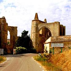
We leave Castrojeriz north-east along the road and after a short time come to the ruins of the former monastery of San Antón, where the road now leads through the middle of the former monastery. From here you should take another look back at Castrojeriz, the cone-like mountain behind it is very impressive. The next place on the way is Hontanas, a small place in a valley. Here it is worth taking a break in the village square with the church and refugio. A few minutes after leaving the village through a ravine, you should take another look back - nothing of Hontanas can be seen anymore. Then, after a short time, the remote pilgrims' shelter "San Bol" follows, a small oasis in this area with a few shady trees and a small stream. Here a German pilgrim, the author of the book "Ich bin mal weg", met a Brazilian pilgrim Claudia from Rio, who then runs like a red thread through his book, but not through his further life.
Places along the route
Castrojeriz - Excolegiata de Santa María Del Manzano - Barrio Del Manzano - Ruinas del Cpnvento San Antón - Hontanas - San Bol - Pozo de Aguas Termales - Val de San Miguel - Hornillos del Camino
Pictures
Facts & figures
Useful apps
We recommend the "Mapy.cz" app for use on smartphones and offline navigation.


