height profile
Description
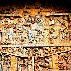
Today we are hiking in the Aveyron department. Our stage destination Conques is not in the Lot valley, but in the valley of the southern Lot tributary «Le Dourdou». Since we are not hiking along the Lot, but over the hills, we come to Conques on a fairly direct route. From Decazeville the path climbs gently to the top, the steeper sections do not await us until the end of the stage. At Noailhac we come across a chapel of St. Roch, a saint who enjoys a considerable reputation in this area and whose name is therefore often encountered. Later, at the height of the valley of the Le Dourdou stream, we come across the Sainte-Foy chapel, which, like the church of Conques, is dedicated to the martyr Foy. Then comes the descent to the «Le Dourdou» brook, which we cross on a bridge from the 15th century. Finally, the final ascent to Conque, where we come across another chapel Saint-Roch. The stage town of Conques is also known as the “pearl on the way from Sanriago to Le Puy-En-Velay, and we will surely share this assessment. The well-preserved Benedictine monastery was built here in the 9th century and is now used as accommodation for pilgrims. The Ste. Foy is particularly known for the tympanum at the west portal, a masterpiece of Romanesque sculpture.
Pictures
Facts & figures
Useful apps
We recommend the "Mapy.cz" app for use on smartphones and offline navigation.


