height profile
Description
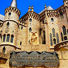
After the strenuous previous stage over the Cantabrian mountains, today we have a comparatively leisurely stage ahead of us - just 20 kilometers, and mostly a gently sloping route. To the east The route leads along a road to Astorga, and occasionally we will cross this road. For the motorists, the Spaniards have invented their own warning sign for “Warning: pilgrims cross the street”, but it doesn't do any harm if the pilgrims themselves watch out when crossing the street. The stage town of Astorga with its massive city walls was already a Roman settlement and became even more important due to the pilgrimage in the Middle Ages. Incidentally, the Via de la Plata from the south of Sapmia also joins our route here in Astotga. The Cathedral of Santa Maria and the Palacio Espicopal are worth seeing, this palace was built by Gaudi when construction began in 1889. Today the Museo de los Caminos is located here.
Places along the route
Rabanal Del Camino - El Ganso - Río de Rabanal Viejo - Santa Catalina de Somoza - La Fontanilla - Murias de Rechivaldo - Ermita Del Eccehomo - Valdeviejas - Astorga
Pictures
Facts & figures
Useful apps
We recommend the "Mapy.cz" app for use on smartphones and offline navigation.


